Product Summary
Create geospatial awareness. Use PASCO’s GPS Position Sensor to collect GPS data simultaneously with other sensor measurements, automatically synch the data to your latitude, longitude, altitude, and velocity.
Two Modes
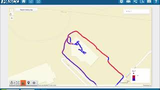
Absolute Position Mode: Pinpoints your location in the world and reports the latitude and longitude within a resolution of 2 meters. Then this data can be imported into ArcGIS online, Google Earth or other virtual globes to overlay all your sensor data on maps or aerial photos.
Relative Position Mode: This special mode enables a higher resolution (0.2 meters) suitable for physics experiments involving bicycles or people running or walking. This mode is used for motion experiments in which the position in the world is not required.
Features
- Velocity is obtained by Doppler from the satellites, not by the calculation of position data.
- The highly sensitive receiver is able to track satellites even under tree canopies.
- An LED indicator indicates whether the GPS Position Sensor is able to triangulate its position.
Measurements Include
- Latitude and longitude
- Elevation
- Velocity (speed and bearing)
- Number of satellites tracked
Applications
- Analysis of the motion and energy of large-scale moving objects (person, car, skydiver, bicycle, boat, etc.)
- Provide spatial information for mapping other sensor data (temperature, water quality measurements, etc.)
How It Works
The GPS Position Sensor uses the Global Positioning System maintained by the U.S. government. The system consists of more than 24 satellites that broadcast ranging signals and other necessary data. For the Position Sensor to determine its own position and velocity, it must receive data from at least three satellites. When the sensor is first powered on, it searches the sky for available satellites. This process typically takes between 30 seconds and 2 minutes. Once satellites have been identified, the sensor actively tracks them and acquires new satellites as they come into view.
What's Included
- 1x PASPORT Sensor Extension Cable
Data Collection Software
This product requires PASCO software for data collection and analysis. We recommend the following option(s). For more information on which is right for your classroom, see our Software Comparison: SPARKvue vs. Capstone »
Interface Required
This product requires a PASCO Interface to connect to your computer or device. We recommend the following option(s). For a breakdown of features, capabilities, and additional options, see our Interface Comparison Guide »
Dedicated Datalogging with SPARK LXi2
Consider an all-in-one, touchscreen data collection, graphing, and analysis tool for students. Designed for use with wired and wireless sensors, the SPARK LXi2 Datalogger simultaneously accommodates up to five wireless sensors and includes two ports for blue PASPORT sensors. It features an interactive, icon-based user interface within a shock-absorbing case and arrives packaged with SPARKvue, MatchGraph!, and Spectrometry software for interactive data collection and analysis. It can additionally connect via Bluetooth to the following interfaces: AirLink, SPARKlink Air, and 550 Universal Interface.